

At Can-Explore, we offer legal surveying services tailored to all your residential projects. Whether you’re building a house or renovating your property, our experts ensure everything is accurately measured and compliant with municipal regulations. With our precise surveys, you can avoid any unpleasant surprises and proceed confidently with your projects.
Legal surveying operations must be carried out by a land surveyor and are defined in Section 34 of the Land Surveyors Act.
Legal surveying for your sector:
Services for the residential sector:
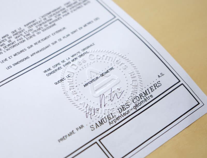
Certificate of Location
An essential document for every homeowner, like a “identity card” for your property. It shows in a single plan all the important aspects of your land and house: boundary lines, buildings, fences, pools, easements (or rights of way), and whether everything complies with municipal regulations. The certificate of location protects you by proving that your home and land are compliant and properly situated. It is an indispensable tool for obtaining a building permit and for managing your property with peace of mind.
Boundary Plan
An official legal document that definitively establishes the exact boundaries of your land. This service precisely defines your property lines, crucial for avoiding neighbor disputes, such as when installing boundary fences. It acts as “undeniable proof” of where your boundaries lie, recognized by you and your neighbors, and is recorded in official registries. Unlike a staking certificate, which temporarily marks boundaries, boundary marking is a legal and permanent process.
Staking Certificate
Before beginning construction or landscaping, a staking certificate delineates the property’s boundaries, ensuring that new structures comply with property limits and current municipal regulations. It physically marks the exact boundaries on the ground (iron rods). In other words, it is a way to “draw” your property in real life.
Topographic and Leveling Plan
These surveys include information about land features, such as flood zones, wooded areas, relief, or waterways. They provide essential data for understanding and working with land in an informed manner.
Cadastral and Subdivision Operation
A cadastral operation is an official process that modifies or updates the public property register, known as the cadastre. This register contains a legal cartographic representation of lands and properties in an area. When carrying out a cadastral operation, you redefine or create land lots to conform to the cadastral system. They are necessary to divide land, merge lots, or update property boundaries.
Technical Description
Technical descriptions are written documents that precisely define the boundaries, characteristics, and details of a property or land. They are essential for notarized deeds, subdividing land, or assessing a project’s compliance with urban planning regulations. Whether for excavation, construction, or public utility installations, they are essential tools for ensuring transparency and legal security in all land-related transactions and projects.
Site Setting Certificate
Before any construction, we prepare a precise site layout plan to position your new construction on the land. A site setting certificate then confirms that the structure complies with setback requirements and local urban planning rules, ensuring that the structure respects the mandatory distances between your building and your property’s boundaries.
Services State-of-the-art tools
Land surveyors master a wide range of technological tools, enabling them to achieve greater speed, precision, and efficiency:
- Global Navigation Satellite Systems (GNSS), which can determine positions anywhere on the earth’s surface.
- Total stations, which measure both angles and distances.
- LiDAR-type laser scanners, which take billions of measurements over a study area and project them in a 3-D environment.
- Drones that provide high-resolution aerial imagery.


When Might You Need a Land Surveyor?
To Install a Fence or Hedge
Before adding a fence or hedge, you’ll want to ensure you’re respecting your property boundaries. A staking certificate can help you accurately locate these limits and avoid any conflicts with your neighbors.
To Add an Extension to Your House or Garage
If you’re planning an expansion, it’s crucial to ensure that your project complies with the setback requirements imposed by your municipality. A site setting certificate confirms that your new construction meets local standards.
To Sell Your House or Land
Selling a property often requires a certificate of location, detailing the current state of your land and structures. This document is essential for ensuring a clear and secure real estate transaction.

To Resolve a Boundary Dispute with a Neighbor
If you and your neighbor disagree about the exact location of your property boundaries, a boundary plan can be established. It officially delineates the properties with the agreement of all parties involved.
For Renovations or Outdoor Projects
Whether installing a pool, deck, or shed, it’s always wise to ensure these additions comply with zoning laws and don’t encroach on neighboring properties.
To Divide a Large Parcel into Several Lots
If you have a large parcel of land and wish to sell a portion or build multiple homes, a cadastral operation is necessary. It allows you to legally create and register new distinct lots.
Our specialized surveying tools
WingtraOne GEN II by Wingtra
The WingtraOne GEN II is a cutting-edge, intelligent mapping drone that offers unparalleled performance for surveying large sites (photogrammetry). This drone maximizes coverage in a single flight, covering up to 460 hectares in one hour, optimizing surveying operations by minimizing labor hours. With its VTOL (vertical takeoff and landing) design, it excels particularly on vegetation-free terrain. The WingtraOne GEN II is equipped with a 61 MP camera, ensuring the highest quality images with an absolute horizontal accuracy of less than one centimeter. Its advanced GNSS PPK technology ultimately eliminates the need for ground control points, further reducing on-site preparation time.

Image courtesy of Wingtra.
Pegasus TRK 700 Neo by Leica
The Pegasus TRK 700 Neo by Leica is a cutting-edge mobile mapping tool capable of capturing over one million LiDAR scans per second. Equipped with artificial intelligence, it is the ideal tool for quickly surveying long road segments. By integrating SLAM (Simultaneous Localization and Mapping) and RTK (Real Time Kinematics) positioning precision, this device references geospatial data with centimeter-level accuracy. Its integrated ISOFIX cameras capture ultra-high-resolution images, enabling detailed 3D visualization of point clouds collected by its LiDAR scanner.
Image courtesy of Leica Geosystems.
NavVis MLX by NavVis
The NavVis MLX revolutionizes 3D reality capture with its advanced handheld technology. Its compact and ergonomic design provides unlimited mobility for surveyors, making it perfect for scanning confined, complex, and hard-to-reach spaces. Featuring a 32-layer LiDAR sensor paired with SLAM (Simultaneous Localization and Mapping) software, this system ensures the highest point cloud quality among comparable tools. Additionally, its four integrated cameras capture high-resolution 360º images, enabling exceptional 3D visualization of the collected data.
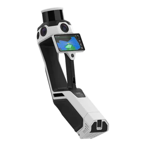
Image courtesy of NavVis.
Request a quote: Land surveyor services
Any questions?
Don’t hesitate to contact us. Our solutions are tailored to your needs.