

Legal surveying encompasses all services that establish the boundaries and dimensions of a private or public property, as required during a sale, purchase, financing, or new construction. The land surveyor is commissioned to perform measurements and surveys, helping to avoid disputes and ensuring the rights and interests of property owners are protected.
Can-Explore provides specialized legal surveying services for the transportation and energy sectors. With our technical expertise and advanced technologies, we assist industry leaders like Hydro-Québec, Gaz Métro, Bell, and Vidéotron in planning, constructing, and maintaining their transportation and energy networks, while ensuring project compliance with current standards and regulations. Discover how our experts can ensure the longevity of your essential infrastructures with impeccable precision.
Legal surveying operations must be carried out by a land surveyor and are defined in Section 34 of the Land Surveyors Act.
Legal surveying for your sector:
Examples of our services for the transport and energy sectors:
Certificate of Location
Transport: Ensures compliance of road and rail infrastructure with property boundaries and public rights-of-way by identifying any easements or servitudes that may affect construction.
Energy: Verifies that substations, power plants, and other energy facilities comply with legal boundaries and regulatory setback distances from adjacent properties.
Certificate of Implementation
Transport & Energy: Creates a detailed plan for the precise placement of infrastructure, ensuring compliance with legal and regulatory requirements. The Certificate of Implementation verifies the alignment and positioning on-site for proper execution of the construction phase. This is especially relevant for large, complex projects like roads, bridges, tunnels, and energy installations (e.g., wind turbines).
Survey Plan and Survey Certificate
Transport: Guides the construction of complex infrastructures such as bridges, tunnels, and roads, ensuring adherence to required alignments and distances. The survey certificate marks these elements on the ground for accurate construction execution.
Energy: Ensures proper placement of high-voltage transmission lines, solar or wind farms, minimizing the risk of encroachment and property disputes.
Cadastral Operation and Subdivision
Transport: Documents modifications needed for road widening, new railway tracks, or optimization of right-of-way areas.
Energy: Updates the cadastral map for new facilities such as wind farms or solar parks, ensuring optimal land management and subdivision for specific uses.
Stakeout Certificate, Property Line Survey Certificate (Staking Certificate)
Transport & Energy : Precisely marks the boundaries of existing or under-construction infrastructure, minimizing the risk of encroachment on adjacent properties. Accurately demarcates facilities, ensuring compliance with original plans and preventing property conflicts.
Topographic Survey and Leveling
Transport: Provides detailed topographic data to optimize the design and layout of roads and railways, considering terrain constraints.
Energy: Assists in the planning of energy projects by incorporating elevation changes, critical for installations such as hydroelectric dams and wind farms.
Rental Space Certification
Transport & Energy: Measures and certifies areas in transport-related infrastructures (stations, airports, etc.) or energy facilities, ensuring accurate space calculations for lease management.
Technical Description
Transport & Energy : Provides a detailed description of land boundaries and key technical characteristics for infrastructure projects in the form of plans and reports.
Land and Technical Expertise
Transport: Evaluates legal and technical aspects of land for road and rail infrastructure projects.
Energy: Analyzes property compliance for energy installations, including geospatial data, topographic surveys, and technical studies.
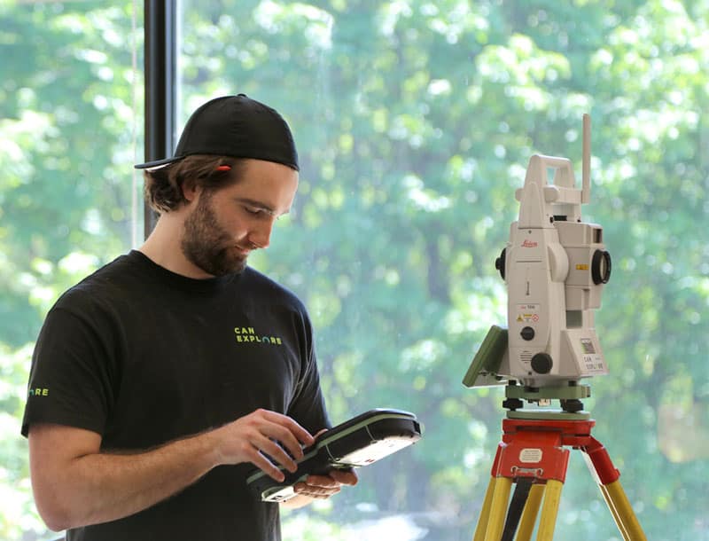
Services State-of-the-art tools
Land surveyors master a wide range of technological tools, enabling them to achieve greater speed, precision, and efficiency:
- Global Navigation Satellite Systems (GNSS), which can determine positions anywhere on the earth’s surface.
- Total stations, which measure both angles and distances.
- LiDAR-type laser scanners, which take billions of measurements over a study area and project them in a 3-D environment.
- Drones that provide high-resolution aerial imagery.


When Might You Need a Land Surveyor?
Validation of Certificates of Location for Existing Infrastructure
Ensure that your roads, railways, or transmission lines comply with cadastral boundaries, municipal regulations, and environmental constraints before commencing modernization or maintenance work.
Planning Network Extensions or New Infrastructure
For the deployment of new electrical transmission lines or transport corridors, we produce precise plans that ensure the route is compliant with regulations and optimized for terrain constraints.
Verification of Compliance with Regulated Zones
Before starting any development project, we analyze the land to identify potential restrictions (flood zones, protected areas, easements) and ensure compliance with regulatory requirements.

Land Acquisition or Disposition for Strategic Projects
For land transactions related to large infrastructure projects, we provide accurate technical descriptions and cadastral subdivisions to ensure smooth and unambiguous management.
Production of Topographic Surveys for Strategic Planning
Our detailed topographic surveys provide the essential foundation for feasibility studies, project design, and optimal routing of infrastructures while minimizing environmental and economic impacts.
Modernization or Maintenance of Existing Infrastructure
Before any work begins, our surveys ensure the precise positioning of existing infrastructures to avoid cost overruns, delays, or boundary disputes.
Our specialized surveying tools
WingtraOne GEN II by Wingtra
The WingtraOne GEN II is a cutting-edge, intelligent mapping drone that offers unparalleled performance for surveying large sites (photogrammetry). This drone maximizes coverage in a single flight, covering up to 460 hectares in one hour, optimizing surveying operations by minimizing labor hours. With its VTOL (vertical takeoff and landing) design, it excels particularly on vegetation-free terrain. The WingtraOne GEN II is equipped with a 61 MP camera, ensuring the highest quality images with an absolute horizontal accuracy of less than one centimeter. Its advanced GNSS PPK technology ultimately eliminates the need for ground control points, further reducing on-site preparation time.
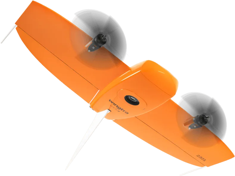
Image courtesy of Wingtra.
Pegasus TRK 700 Neo by Leica
The Pegasus TRK 700 Neo by Leica is a cutting-edge mobile mapping tool capable of capturing over one million LiDAR scans per second. Equipped with artificial intelligence, it is the ideal tool for quickly surveying long road segments. By integrating SLAM (Simultaneous Localization and Mapping) and RTK (Real Time Kinematics) positioning precision, this device references geospatial data with centimeter-level accuracy. Its integrated ISOFIX cameras capture ultra-high-resolution images, enabling detailed 3D visualization of point clouds collected by its LiDAR scanner.
Image courtesy of Leica Geosystems.
NavVis MLX by NavVis
The NavVis MLX revolutionizes 3D reality capture with its advanced handheld technology. Its compact and ergonomic design provides unlimited mobility for surveyors, making it perfect for scanning confined, complex, and hard-to-reach spaces. Featuring a 32-layer LiDAR sensor paired with SLAM (Simultaneous Localization and Mapping) software, this system ensures the highest point cloud quality among comparable tools. Additionally, its four integrated cameras capture high-resolution 360º images, enabling exceptional 3D visualization of the collected data.
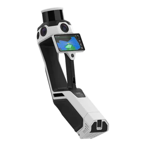
Image courtesy of NavVis.
Request a quote: Land surveyor services
Any questions?
Don’t hesitate to contact us. Our solutions are tailored to your needs.